Posted in Blog |
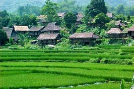
Introduction Hoa Binh is a mountainous province located in the north. It is bordered by Son La in the west, Phu Tho and Ha Tay in the north, Ha Nam and Ninh Binh in the east, and Thanh Hoa in the south. The culture of Hoa Binh combines six minorities with their own languages, traditional literature, and festivals. The climate is hot and humid with high levels of precipitation during the rainy season. Several calamities such as heavy rains, floods, violent storms, and droughts occur in this area. Tourists especially enjoy the minority specialty dishes including rice cooked in bamboo and grilled meat. They also enjoy watching traditional dancing, music performances (bronze, drums, gongs), and Thai minority singing and dancing. The remote minority villages are attractive sites for tourists. Located on Highway 6, Hoa Binh provincial is 70 km south-west of Hanoi. Hoa Binh town and the adjacent area was the cradle of the Hoa Binh culture. Archaeological finds show that this is the first place man domesticated crop plants. Hoa Binh province is inhabited by various ethnic groups, the Muong, Kinh, Thai, Tay, Dao, H’Mong and Hoa. Transportation Hanoi-Hoa Binh: 76 kilometers a, Motorbike You can go by motorbike; it is suitable for visiting all landscape in Hoa Binh. b, Bus From Hanoi to Mai Chau, you must pass 76 kilometers to the Hoa Binh town. Highway 6 from Hanoi to Hoa Binh. What to see Mai Chau Mai Chau is located around 135km from Hanoi at Hoa Binh province, stay in a peaceful valley sheltered by the outside world by a dramatic ring of hills. On the way coming to Mai Chau , you will have chance to pass through the top of Cun mountain, from there you can take a fabulous overview of the valley with the houses on stilt and paddy fields, bring the first impression about culture of Mai Chau –Hoa Binh. Mai Chau brings a different image about Vietnam , inhabited with minority groups, that mainly Thai people ,Thai minority is one of six minority groups at Hoa Binh province. Thai people are livingat small villages like: Lac village, Pom Coong village, Van village, Buoc village …. , these villages make a community with lot of particular culture and festivals. Thai people devided into 2 groups White Thai and Black Thai, use their own language beside King language . Kim Boi hot spring Kim Boi hot spring belongs to Kim Boi district, Hoa Binh Province. It is natural mineral hot spring and good for human health. Kim Boi mineral water is eligible for drinking, bathing, soaking and it can treat stomachache, blood pressure… With an area of 7 hectares, this is a rustic resort that is peaceful and exciting. Kim Boi mineral spring flows deep underground so that the mineral water has a temperature of 340C-360C. Coming to hot spring, you can register...
Read More »
Posted in Blog |
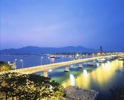
Introduction of Da Nang City in Vietnam. This is an article from Sapa Travel Vietnam Da Nang is one of the cultural and educational centers of Vietnam, and it is also one of the biggest cities in Vietnam. Da Nang has a long coast with many beautiful beaches such as Non Nuoc, My Khe,… Coming to Da Nang, you will have opportunities to enjoy the beautiful scenery such as Ngu Hanh Son, Ba Na, Son Tra peninsula, Hai Van pass, beaches and many historical relics. The city is located along Han River so that the French often called Da Nang as “Tourane”. Da Nang has an area of 1.200 km2 and its total population is about 800.000 people. It is not only convenient location but also easily accessible port. Situated on the path of national route 1A and the North-South railway, it is known as a hub for transportation. Da Nang city shares the border with Thua Thien Hue in the North, Quang Nam province in the South and The Eastern Sea. It is far 764 kilometers from Hanoi to the North, 964 kilometers from Ho Chi Minh City to the South and 108 kilometers from Hue ancient capital to the North-South. Da Nang terrain has either coastal or mountains. The high and slope mountain is in the South and North-South, from here, many mountains lasts to the sea. The mountainous terrain accounts for large area with the high of 700-1.500 meters. Da Nang is situated in the typical tropical monsoon area with the high temperature. Its temperature has combination between the Northern climate and Southern climate. Every year, there has 2 seasons: the rainy season lasts from August to December and the dry season lasts from January to July. The average temperature is about 25,90C and the highest temperature is in June, July, and August at 28-300C. The area of Ba Na has the temperature about 200C. The average rainfall is 2.504,57 mm and the highest rainfall is in October and November. How to get there By plane Da Nang International Airport (IATA: DAD) is the smallest of Vietnam’s three international airports. There are frequent flights to Hanoi and Ho Chi Minh City on both Vietnam and Jetstar Pacific, as well as domestic service between Buon Ma Thuot, Da Lat, Hai Phong, Nha Trang and Pleiku and internationally Guangzhou, Seoul-Incheon, Kuala Lumpur, Shanghai-Pudong, Siem Reap, Singapore, Taipei and Tokyo-Narita. Aside from a money changer, airport amenities are rather minimal, although some upgrading was done to the airport in late 2007 and early 2008 making the airport one of country’s most modern. As of November 2006, international departure taxes should be included in the price of your ticket. Compared to larger Vietnamese airports, Da Nang is a little bit laid back; local travelers often arrive less than 30 minutes before their flights; there are also a couple of restaurants/coffee...
Read More »
Posted in Blog |
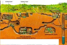
The article about Cu Chi and the tunnels by Sapa Travel Cu Chi is about 40 km northwest of Ho Chi Minh City in Southern Vietnam. The Cu Chi Tunnels are an elaborate underground community made up of 250 km of tunnels and chambers below the city. The tunnels were dug with simple tools and bare hands during the French occupation in the 1940s, and further expanded during the Vietnam War in the 1960s to provide refuge and a defensive advantage over the American soldiers. Despite all the bombings in their town, the Cu Chi people were able to continue their lives beneath the soil, where they slept, ate, planned attacks, healed their sick, and taught their young. Some even wed and gave birth underground, but over 10,000 lost their lives here. How to get there A multitude of tour buses leave Ho Chi Minh City for the Cu Chi tunnels daily. Expect to pay around US$5 for a half day guided trip (not including admission to the tunnels), with 90 minutes travel and about an hour and a half touring the area. Buses mostly leave around 8:00, so consider a private car if this isn’t suitable. Tour operators on Pham Ngu Lao will quote from $45-75 return by private car, or possibly lower — don’t be afraid to shop around. If you’re making the trip independently, hop on bus 13 from the Ben Thanh bus station. The last stop on the route is Cu Chi. Bus fare is 7,000 VND, and the ride is about 1.5 hours. When you arrive at the Cu Chi bus station negotiate a motorbike driver for the 20-minute ride for around 100,000 VND return (pay attention as starting price could be 200,000 VND or more). It is also possible to take bus 79. Ask the driver for Cu Chi tunnels, the ride will last about 45 minutes and cost 5,000 VND. The bus will reach a T-junction with Ben Duoc on the left and Ben Dinh on the right. Get off at this point and walk on to Ben Dinh, or stay on the bus as it drives right pass the Ben Duoc entrance. Warning, the buses are sometimes very warm and crowded but manageable. Admission to the tunnels is 90,000 VND as at Febuary 2013, which includes a guide who may or may not speak English well. While friendly, these guides may attempt to rush the tour or distance you from paid guides/groups — just indicate that you aren’t ready to move on yet and take your time if you feel you’re being rushed. There are actually two locations frequented by tourists: Ben Duoc This is further out from Ho Chi Minh and many local Vietnamese go there. Tour companies can organize a day tour on demand, but you would be better off hiring a motorbike. Entrance is 80,000 dong and a motorbike...
Read More »
Posted in Blog |
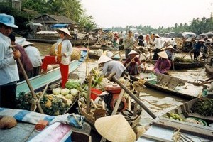
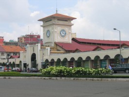
The article about Can Tho in Mekong Delta by Sapa Travel Can Tho is the biggest city of the Mekong Delta, in Vietnam with an estimated population of 1,5 million as of 2012. The name comes from “cầm thi giang” – river of poems. It is also referred to as “Tay Do” meaning “Western capital”. The city is famous for its floating markets, Buddhist pagodas, delicious food and fresh fruits and the beauty of the Mekong girls. Can Tho is located on the south bank of the Hậu River, the bigger branch of the Mekong River. It is in vicinity to Sóc Trăng, 1.5 hours from Long Xuyen, 3 hours from Châu Đốc and Rạch Giá, about 6 hours from Cà Mau, and 169 km (3 hours) from Ho Chi Minh City. The climate is tropical and monsoonal with two seasons: rainy, from May to November; and dry, from December to April. Average annual humidity is 83%, rainfall 1,635 mm and temperature 27 °C. How to get there By Express Bus Many operators serve Can Tho from cities in the Mekong Delta up to the center and north of Vietnam. You may have a short stop in Ho Chi Minh City. Most travelers arrive in Can Tho from Ho Chi Minh City. From Ho Chi Minh City bus operators servicing Can Tho are leaving every one to two hours around the clock from the Western Bus Station (Bến Xe Miền Tây). Prices are US$4-7. Smaller more local buses from Saigon to Can Tho leave in the morning. There are three main operators servicing routes from Ho Chi Minh City as well as other destinations – “Thanh Buoi”, “Phuong Trang” and “Mailinh”. The big operators also have a departure point in the center of the city at Le Hong Phong street, from where shuttle buses will bring you to Bến Xe Miền Tây. You can take a taxi to Le Hong Phong street in district 10. Look out for the office of “Thanh Buoi” (white background logo with a flower), “Phuong Trang” (red signs) or “Mailinh” (all green) or go straight to Mien Tay bus station in district 6. The taxi from district 1 costs around US$12 in May 2012. With most operators you will get a small bottle of water included in your ticket price. Bigger buses offer AC, but also entertainment program of Vietnamese films and music shows, which are usually perceived as too loud for “Western ears”. Major Bus Operators Thanh Buoi is providing the fastest service to Can Tho as the bus only stops for a 10 minutes on the way from Ho Chi Minh city. The ride takes about 3 hours. The company provides a small bun as a free snack and free water for customers. At the arrival in Can Tho shuttle buses bring you to your final destination inside the city. Have the...
Read More »
Posted in Blog |
Introduction of Ho Chi Minh City, Vietnam. This guide is from Sapa Travel, travel blog and information Ho Chi Minh City, formerly named Prey Nokor, Saigon , is the largest city in Vietnam. Under the name Saigon, it was the capital of the French colony of Cochin-china and later of the independent republic of South Vietnam from 1955–75. South Vietnam, as an anti-communist, capitalist republic, fought against the communist North Vietnamese and Viet Cong during the Vietnam War, with aid from the United States and countries including Australia, New Zealand and South Korea. Saigon fell when it was captured by the communists on 30 April 1975, ending the war with a Communist victory. Vietnam was then turned into a communist state with the South overtaken. On 2 July 1976, Saigon merged with the surrounding Gia Định Province and was officially renamed Ho Chi Minh City after Hồ Chí Minh (although the name Sài Gòn is still commonly used). The metropolitan area, which consists of the Ho Chi Minh City metropolitan area, Thủ Dầu Một, Dĩ An, Biên Hòa and surrounding towns, is populated by more than 9,000,000 people, making it the most populous metropolitan area in Vietnam. The city’s population is expected to grow to 13.9 million in 2025. The Ho Chi Minh City metropolitan area, a metropolitan area covering most parts of Đông Nam Bộ plus Tiền Giang and Long An provinces under planning, will have an area of 30,000 square kilometers with a population of 20 million inhabitants by 2020. According to the Mercer Human Resource Consulting, Economist Intelligence Unit and ECA International, Ho Chi Minh City is ranked 132 on the list of world’s most expensive cities for expatriate employees. Geography Ho Chi Minh City is located in the southeastern region of Vietnam, 1,760 km (1,090 mi) south of Hanoi. The average elevation is 19 metres (62 ft) above sea level. It borders Tây Ninh and Bình Dương provinces to the north, Đồng Nai and Bà Rịa–Vũng Tàu provinces to the east, Long An Province to the west and the Indochine to the south with a coast 15 km long. The city covers an area of 2,095 km2 (809 sq mi) (0.63% of the surface of Vietnam), extending up to Củ Chi (12 mi (19 km) from the Cambodian border) and down to Cần Giờ on the Bien Dong coast. The distance from the northernmost point (Phu My Hung Commune, Củ Chi District) to the southernmost one (Long Hòa Commune, Cần Giờ District) is 102 kilometers (63 mi), and from the easternmost point (Long Binh Ward, District Nine) to the westernmost one (Bình Chánh Commune, Bình Chánh District) is 47 kilometers (29 mi). Climate The city has a tropical climate, specifically a tropical wet and dry climate, with an average humidity of 75%.[20] The year is divided into two distinct seasons. The rainy season, with an...
Read More »
Posted in Blog |
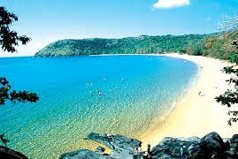
Today, Sapa Travel will show you how to travel Con Dao Island and when to visit Introduction Con Dao islands are a group of 16 islands. The largest island is known as Con Son. Con Dao served as a prison island for political prisoners during the French colonial era, when it was known as Poulo Condore, and in later years the Saigon regime imprisoned opponents of the regime in the infamous cells known as the “tiger cages”. The old prison buildings are still standing and are open to the public as is a small museum tracing the island’s history. Besides having an interesting history, Con Dao is also an island of immense natural beauty with forested hills, deserted sandy beaches and extensive coral reefs making for some excellent diving. Con Dao is another sad example of a National Park doing nothing to preserve the environment, however due its remote and little known location it has been preserved (So far) from the effects of development. 80% of the land area of the archipelago is a National park offering primary jungle teeming with interesting life such as the endemic black squirrel and the crab eating macaque. Beautiful beaches and hidden lagoons are also to be found here, with very few tourists Con Dao is a paradise off the beaten track. For now at least. Most of the surrounding marine are is a no-take marine protected area (MPA). Sadly as in all of Vietnam the national park is a travesty. The national park is in no way responsible for the amazing health of the pristine reefs that surround the islands, home to a large variety of marine life incomparable to anywhere else in Vietnam. Con Cao National Park is currently under going scrutiny of its operations by the World Wildlife Fund and The United Nations Development Program, both groups played a key role in the set up of the National park. Recently funding was withdrawn by another key aid organization DANIDA, as evidence was produced that they were operating in violation of their charter and that the Park was run for personal profit at the expense of the environment. Consider carefully and ask around on the island before using any of the National Park services. International oversight is desperately needed to be sure the environment abuses are halted. Recent reports to the National Park of the spotting of slaughtered turtle shells drying in the sun on the roof of the Anh Dao hotel have produced no inquiry, investigation or prosecution of the hotel. How to get there Con Dao Airport (IATA: VCS) is served by VASCO (a Vietnam Airlines [http://www.firstchoice.vn/vietnam/flights/ ) Flights operated by VASCO (Vietnam Airlines) may be booked at Vietnam Airlines offices or through most tour operators in Saigon. It may be better to book through an official Vietnam Airlines office or through their official website to avoid complications or...
Read More »


