Posted in Blog |
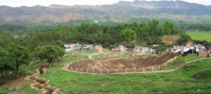
Introduction Dien Bien Phu is famous as a battlefield that was truly decisive. The French colonial forces were roundly defeated at the hands of the Viet Minh on 7 May 1954 and the days of their Indochina Empire were finally numbered. Like Hanoi and Ho Chi Minh City, Dien Bien Phu now enjoys the prestigious status of provincial city, although it is not quite in the same league. Set in one of the most remote parts of Vietnam, the town is 34km from the Laos border in the flat, heart-shaped Muong Thanh Valley, surrounded by steep, heavily forested hills. The size and look of the city is surprising considering the remote location, especially if you managed to survive getting here overland. History is the main attraction in Dien Bien Phu and the scenery is more stunning on the journey to or from Dien Bien Phu than around the town itself. Not surprisingly, the majority of travelers who come here now are French – Dien Bien Phu seems to hold the same sort of fascination for them as the Demilitarized Zone (DMZ) does for Americans. For a long time Dien Bien Phu is also a point of cultural and economic exchange between people in the border area of Vietnam, Laos and China, it was also an area of power dispute between land lords. The area is inhabited by Montagnards, most notably the Thai and H’mong. The government has been encouraging ethnic Vietnamese to settle in the region. So visiting Dien Bien Phu, travelers not only visit the historical battlefield, but also have something in mind about the life of local people here. How to get there The overland trip to Dien Bien Phu can be more intriguing than the actual battlefield sites for which the town is so celebrated. Of course, you miss out on this if you fly. Land Bus The bus station is on Highway 12, at the corner of Tran Dang Ninh. There is a direct bus service that runs from Hanoi to Dien Bien Phu (14 hours) leaving at 6am and 8am. Buses to Muong Lay (three hours) leave in the morning. Daily buses to Son La (four hours) start at 4.30am, but for normal people who like to get up at normal times there are regular departures until noon. Although the bus is cheap, it’s not really much fun. Buses are so packed that the only scenery you get to admire is the armpit of the person sitting next to you. If overloaded vehicles, bad roads and bad brakes worry you, definitely fly or travel overland by 4WD or motorbike. Car & motorbike The 470km drive from Hanoi to Dien Bien Phu on Highway 6 and 42 takes at least 12 hours (if you’re lucky). Conceivably it could be done in a single direct journey, but almost everyone stays overnight in Son La. Speaking from...
Read More »
Posted in Blog |

Introduction Dalat, also Da Lat (Đà Lạt), located in the South Central Highlands of Vietnam, was originally the playground of the French who built villas in the clear mountain air to escape the heat and humidity of the coast and of Saigon, officially known as Ho Chi Minh City. Dalat looks like a cross between Vietnam and the French Alps. Many of its hotels and houses are built in a European/ French style. The city spreads across a series of pine-covered hills, with a small lake in the center and surrounded by a man made lake and higher peaks, making for some lovely scenery quite different from the rest of Vietnam. Temperatures are pleasantly warm by day, and quite cool at night, down to perhaps 10 degrees Celsius. Dalat is very much a niche tourism town, open to some of the more adventurous travelers, or the Indochine romantics, seeking world class golf. There is a steady flow during some parts of the year of tourist from all walks of life and places, small hotels, cafe’s lining its streets and plenty of small shops offering anything from orchids to knitwear. The vast majority of visitors are Vietnamese, although plenty of Americans and Europeans find their way, in their search for this utopian Dalat, a Life style resort destination, either on short package tours, or research and soul searching, drawn by the scenery, vivid blue skies, fresh air, flower-filled parks, and local culinary treats. Dalat is a favorite destination for company weekend outings, family get-aways, and honeymooners. Most guidebooks for overseas visitors describe Dalat as a tourist town with a colorful approach to tourism. Dalat is a very pleasant stop, on a north-south tour (or vice versa), or a pleasant outing from the heat of Saigon. For overseas visitors, it offers mostly a chance to cool down, observe the Vietnamese at play, view a bit of the French legacy, the Indochine legend and its momentous glories and the architecture untouched by the Vietnam conflict left behind,a unique place to enjoy the atmosphere of a unique country and its people. Dalat is also surrounded by some of the best mountain biking, hiking and canyoning opportunities in Vietnam, with hills of coffee and tea plantations, which evoke images of the colonial hill stations of the north of India. Dalat’s high altitude (1500-2000 m) and fertile landscape make it one of Vietnam’s premier agricultural areas, producing varieties of fruits, vegetables, tea, coffee and flowers that don’t grow in the lowlands. In markets as far north as Hanoi and Hai Phong, vegetable and flower vendors will tout their “made in Dalat” produce. How to get there Most local and foreign travellers arrive in by bus, including those travelling on the famous Sinh Cafe Hanoi-HCMC open-tour bus. Mai Linh Express and Phuong Trang run several daily services to Dalat from Nha Trang and HCMC. From Nha...
Read More »
Posted in Blog |
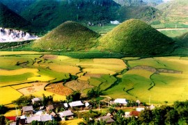
Introduction Ha Giang is a province in northeastern Vietnam, bordering Cao Bang province in the east, Yen Bai and Lao Cai province in the west and Tuyen Quang in the south. Northern Ha Giang province share the border with China (border length 274 kilometers) The topography of Ha Giang province is complex; it can be divided into three regions: upland mountain in the north, valley and rivers. Its climate is moderate, divided into 2 seasons: rainy and dry seasons. Western upland of massif upstream of Chay River, steep slopes, narrow valleys and streams, which was divided into two seasons: rainy and dry seasons. Lowland in the province includes hills, Lo River and Ha Giang town. The average temperature is about 240C-280C, in the winter, temperature can go down to -50C. According to census on April 1st 2009 Ha Giang population is 724.537 people in which H’Mong accounts for 32% total population, Tay (23.3%), Dao (15.1%), Viet (13.3%) and Nung (9.9%) Ha Giang has many mountains such as Tay Con Linh with 2.419 meters height, there has many old growth forests, many precious wood, and 1.000 kinds of rare herbs. The animal includes tiger, hemorrhoids, phoenix, pangolin… and hundreds of other birds. Ha Giang has poetic and grandeur upland: Dong Van, Khau Vai love market which attracts a numbers of tourists. Coming to Ha Giang, tourists have opportunity to access the unique culture and traditional products such as: bags, dresses with brilliant pattern. Moreover, tourists can enjoy the fair of uplands and explore exciting experience. The newly-built house ceremony of the Lo Lo is a highlight of Ha Giang. It lasts about 2 days 2 nights at the new home of the Lo Lo. All people in village pull to celebrate the new house. Spring festival is the festival of H’Mong and Dao, it usually held on the day after lunar New Year and lasts from 3 to 7 days. The festivals include crossbow, throwing pa pao’, and drinking wine… . In brief, Ha Giang has many unique traditional heritages of more than 20 ethnic, a memorable destination by the natural landscape. Transportation Hanoi – Ha Giang: 318 kilometers a, Motorbike b, Bus Price ticket: 160.000vnd-180.000vnd Time: 3:00am-5:30 am From Hanoi to Ha Giang, you must pass more than 300 kilometers to the town then turn up 4C province deeply in the remote of arctic land. Best time to come to Ha Giang is in November when the rice is in the harvest, flower blooms in the field and the rainy season is over. What to see Dong Van karst plateau Dong Van karst plateau has an area of 2.350 square kilometers, spreads over four districts of Ha Giang province: Quan Ba, Yen Minh, Dong Van and Meo Vac at an average height of 1.400 – 1.600 meters with a number of beautiful limestone and winding road. Here, scientists have...
Read More »
Posted in Blog |

Introduction Ninh Binh is the capital city of Ninh Binh Province in North Vietnam, famous for the nearby Karst scenery and the village of Tam Coc. There is nothing to do in Ninh Binh itself aside from drinking beer with the locals; the town is more useful as a base for the surrounding countryside. How to get there By taxi Taxis from Hanoi costs US$68 Taxis from Noi Bai international airport cost $85 usd , 2 hour journey By bus There are regular buses from Hanoi’s southern bus terminal (Giap Bat) that leave every 15 min (or whenever full) 60,000 Dong. Note that this may rise to 90,000 per person with luggage.Journey time for the 90km is 1.5-2.5 hr traffic depending. Buy a ticket in the ticket hall or you will likely have to pay more than 60,000 or be removed from the bus.the service is slow but relaxed and comfortable using one of the very common Hyundai 20-odd seat buses. Open tour buses will drop passengers off upon request (Ninh Binh is not a regular stop). Most open tour buses from Hanoi will arrive at 9:30PM. Tour buses from Hue arrive at a rather early 4AM. From Cat Ba island you can book a bus-boat-bus-bus ticket for 230,000 dong. Leaves at 9am and takes about 5h. Seems to be the easiest and cheapest way. The first bus takes you the harbour where you transfer onto a boat (and at times from that boat to another boat) to Haiphong’s Ben Binh harbour. The second bus takes you to a bus station called Bến xe Niệm Nghĩa which is quite far from the harbour and turns out not that convenient on a DIY trip. From there you wait for the bus to leave at 12pm. Seats are tiny even for small westerners. Drops you at Ninh Binh bus stations, walking distance from hotels and hostels. All the above uses local transports so expect locals boarding at various places. Alternative buses including tourist ones leave from Haiphong a few times a day. By train Ninh Binh is a regular station for the Reunification Express, with trains coming from both North and South. It is usually a quick stop, with few people getting off, especially at night, so get off quick or miss the stop. Hard Seat 35-45,000 depending on train number 2-2.5 hours. How to get around By motorbike A motorbike is the best way to view Ninh Binh and the surrounding areas. Most hotels can arrange for a motorbike driver/guide to take you around the sites for about US$15 a day. Hire a motorbike (commonly Honda 110cc) for 100,000 Dong. These take 3 litres of fuel costing 50,000 which will last a day of exploring.The local roads are bad, the local driving ranges from nuts to insane. By bicycle Cycling is a good option for visiting nearby sights. Finding a...
Read More »
Posted in Blog |
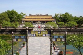
Introduction Hue is in the central region of Vietnam and is the former imperial capital. Hue is intimately connected to the imperial Nguyễn Dynasty, based in Hue, who ruled from 1802 to 1945, when the Emperor Bao Dai abdicated in favor of Ho Chi Minh’s revolutionary government. The city went through tough times during the Vietnam War, when it was conquered by the Viet Cong and held for 24 days, during which the VC slaughtered around 3,000 people suspected of sympathizing with the South, being a highschool graduate or Christian. In retaking the city American forces initially didn’t use artillery or air support to avoid damaging ancient buildings but due to heavy casualties these restrictions were relaxed and the city largely destroyed. Orientation Hue is easy to get a grip on. The main landmark is the Perfume River (Hương Giang), with the old city and the Citadel on the north side and the newer city, including most hotels and restaurants, on the south side. Much of the riverside has wisely been done up as a pleasant promenade and park dotted with bizarre sculptures. The tombs are located further south in the outskirts of Hue. Climate Hue’s weather is infamously bad: the Truong Son Mountains just to the south seem to bottle up all the moisture, so it’s usually misty, drizzly or outright rainy. Things get even wetter than usual in the winter rainy season, especially from February to the end of March. To be safe, bring along an umbrella any time of year. Don’t forget to bring a sweater and jacket in winter as it can get rather chilly, with temperatures falling to as low as 8 degrees at night. Alternatively, when the sun makes an appearance for a day or a week, it can reach 30 degrees. It’s usually quite dry during the summer months, when the temperature can reach the high 30’s. Summer rains can be heavy but brief, and often arrive unexpectedly, whereas February rains can last for weeks. The best description for the weather in Hue would be “changeable”. How to get there By plane Hue’s international “Phu Bai” airport fields daily flights to and from Ho Chi Minh City and Hanoi, but flights are quite often disrupted by poor weather during the rainy season (Mid October – Mid December). The majority of flights are Vietnam Airlines but Jetstar Vietnam also runs a flight or two from Ho Chi Minh City and once a day to Hanoi. The airport is 15 kilometers away from the city center and should cost no more than 180,000VND by taxi (30 minute ride). There is also a bus that will take you into the city & even drop you at your hotel for 50,000VND. You can buy a ticket in the arrival hall of the airport. The airport facility is currently undergoing renovations and will be closed until 13...
Read More »
Posted in Blog |
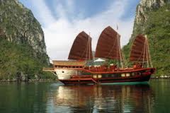
Named and designed after an authentic Chinese junk, the original Red Dragon junk plied the rivers, seas and harbors of the Far East, from Singapore to northern China. Our Red Dragon is complete with five deluxe cabins and designed to resonate with superior class and grandeur. Larger than The Prince and Princess it is still small enough to get up close to the natural wonders, pocket lagoons and small fishing communities of Halong and Bai Tu Long bays. As soon as you board the Red Dragon, you will be surrounded by traditional handmade artisan woodwork. Whether you are relaxing in the comfort of your own cabin, lounging on the spacious sun deck, or dinning in the cozy restaurant, you will feel treated like royalty. This masterpiece is a wonderful option for those who need a little more space for a small group cruise of up to 11 people. Safety Notice 1. Particular individuals For safety reasons, these below Guests are not recommended to cruise overnight in Halong Bay: People with disability, such as blindness, two hand amputee. People who are unable to walk on 2 m high stairwells People who have health problems, including people with sleepwalking syndrome, people who have Illusions, people with epilepsy, people who have got anxiety when being in a small place. People who are on medicines that need to be stored at a special temperature and without it their lives are in danger People who is older than 80 People who is more than 100kg weight People who is over 2 meters height 2. Poisonous plants and animals During summer, especially May, June, July, before going to swim, Guests should ask the guide or captain for advice because it is when the poisonous jellyfish are most active 3. Emergency Storms: when storms come during the tour Guests should be calm and follow instructions of the captain and guide. Guests need to move to the highest open areas of the boats or clear space or dining areas When engines are heard operating at night when the boat is anchored Guests need to rush out of their cabins because a storm is possibly coming or there is a potential boat collision. 4. Safety Facilities Life vest in each cabin, at public area, life buoys, life raft that enough for guests and crew on board. Lighters and hammers for emergency case in each cabin. Fire alarm, fire extinguishers at different areas on board, following the standard guide and ready to use Diagram to exit in emergency case . Marine equipment: VHF radio, GPS plotting, walkie-talkie, Walter licking alarm system, water pump system, fire alarm system and fire extinguishers. 5. Onboard safety Brief introduction about the trip with itinerary, crews, activities and safety, weather information Activity warning: our guide will give short introduction and warning to visitors, depending on weather conditions and seasons features, we recommend you to...
Read More »


